Since February 2025, Carbon Mapper’s Tanager-1 satellite has detected methane emissions eight times at a facility near Ringgold, Louisiana. The average estimated emissions rate across the eight detections was 1,200 kilograms of methane per hour, an emissions rate that classifies this event as a super-emitter. In November 2026, Earthworks visited the facility and used specialized optical gas imaging cameras to confirm that the facility was still emitting methane.
Together, these repeated observations suggest that methane emissions at this facility may be persistent, meaning that they continue or recur over an extended period of time.
Over the past decade, research by PSE Healthy Energy has shown that methane emissions from oil and gas facilities are almost always accompanied by hazardous air pollutants, including benzene. Our research has also shown that people living near oil and gas operations can be exposed to elevated concentrations of these pollutants, increasing their health risks.
PSE developed the Methane Risk Map to analyze how methane super-emitter events can affect air quality and human health in nearby communities. Due to the intermittent nature of satellite methane detections, the tool currently focuses on short-term, or acute, health risks by estimating hourly concentrations of hazardous air pollutants associated with methane emissions and comparing them to short-term, health-based benchmarks.
But what happens when a methane leak continues for days, weeks, or months? Could longer-lasting emissions expand the area where hazardous air pollutants pose health risks and put more people at risk?
To explore these questions, we took a closer look at the repeatedly detected methane super-emitter near Ringgold, Louisiana.
Longer-Lasting Methane Super-Emitter Events Could Affect More People
When methane is emitted from oil and gas facilities, hazardous air pollutants associated with methane emissions, including benzene, toluene, ethylbenzene, and hexane–can pose health risks to the reproductive, immune, hematologic, nervous, and respiratory systems.
Our previous research has shown that even short-lived methane super-emitter events can pose health risks to nearby communities. But when emissions persist for days, weeks, or months, the potential impacts can change in two important ways.
First, the wind doesn’t always blow in the same direction. During a short-lived event, pollutants may travel in a relatively narrow area downwind of the source. Over longer periods, shifting wind directions can carry pollutants into different areas, potentially affecting more people.
Second, the longer emissions continue, the greater the potential for prolonged exposure. This makes it important to consider health risk benchmarks designed for longer exposure durations, which can often be lower than benchmarks for short-term exposures. For example, the California Office of Environmental Health Hazard Assessment (OEHHA) has established a health benchmark of 8 parts per billion (ppb) for benzene exposure lasting one hour. For eight-hour exposures, the benchmark is lower, at 1 ppb.
To understand what these differences could mean for nearby communities, we modeled two scenarios at the methane super-emitter site near Ringgold, Louisiana: one in which emissions lasted for a day and another in which they continued for a month.
A Month-Long Methane Emissions Event Could Pose Health Risks to About 400 More People Than a One-Day Event
We found that if methane emissions lasted for one day, the benzene risk area, defined as the area that exceeds the relevant health benchmark for benzene, is relatively narrow, extending approximately 1 mile from the facility. In this scenario, benzene concentrations exceeded the 8 ppb, 1-hour health benchmark in an area where fewer than 100 people live.
However, if emissions continued for one month, changing wind directions could spread hazardous air pollutants across a much larger area. When we account for these changes and consider the 1 ppb, 8-hour health benchmark, the modeled risk area extends up to 6 miles from the facility.
Overall, we found that the health risk area in the one-month scenario is approximately 20 times larger than in the one-day scenario. We also estimate that 420 people live within this larger risk area of the one-month scenario.
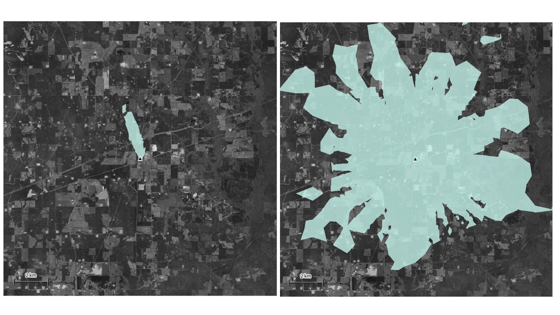
Caption: Modeled benzene concentrations from a methane super-emitter near Ringgold, Louisiana, under two emissions scenarios: one day (left) and one month (right). Blue shading indicates areas where estimated benzene concentrations exceed the relevant health benchmarks.
These scenarios show how persistent methane emissions can expand the area where hazardous air pollutants may pose health risks. As wind directions change over time, air pollutants can be dispersed to where more people live, work, and breathe, while longer exposure durations make more protective health benchmarks relevant. Together, these factors explain the 20-fold increase in the modeled risk area, rather than emissions duration alone.
Identifying and Repairing Persistent Methane Super-Emitters Can Reduce Health Risks
The Ringgold example highlights the importance of identifying and repairing persistent methane leaks quickly to protect nearby communities. However, because satellites capture only snapshots of emissions, it can be difficult to determine how long a leak has persisted or whether emissions have continued between detections.
As more methane-monitoring satellites, including Carbon Mapper’s Tanager-2, come online, researchers will have new opportunities to better characterize persistent emissions, identify potential health risks, and investigate longer-term health risks for communities living near oil and gas infrastructure.
More About the Methane Risk Map
The Methane Risk Map is an interactive tool developed by PSE Healthy Energy to better understand the air quality impacts and human health risks associated with methane super-emitter events.
The tool combines methane emissions data captured by satellites and aircraft and made available through Carbon Mapper’s Data Portal, PSE Healthy Energy’s research on hazardous air pollutants in natural gas at production facilities, and our regulatory-grade air quality modeling approach to estimate where hazardous air pollutants may exceed health-based benchmarks. Users can interactively explore the modeled risk area of individual methane emissions events, review the characteristics of nearby residents, and identify sensitive locations such as schools, hospitals, parks, and prisons. Our methods are described in PSE’s Methane Risk Map product guide.
One of the eight methane super-emitter events detected at the potentially persistent emissions source near Ringgold, Louisiana, occurred in May 2026. For this event, the Methane Risk Map estimated that benzene concentrations exceeded California OEHHA’s 8 ppb, 1-hour health benchmark across an area of 1.4 square miles. Because the facility is relatively remote, fewer than 100 people lived within this risk area. While this analysis captures the potential short-term health risks associated with a single emissions event detection, the repeated detections at this facility highlight why it’s important to understand how persistent emissions could expand the area of concern over time.
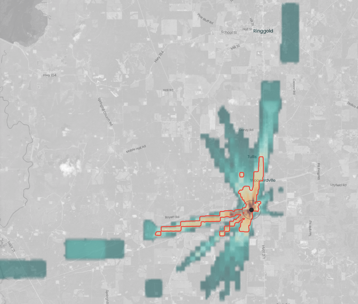
Caption: Methane Risk Map showing the modeled air quality impacts of a methane super-emitter event detected near Ringgold, Louisiana, in May 2026. The dashed red line outlines the area where estimated benzene concentrations exceed California OEHHA’s 8 ppb, 1-hour health benchmark. Explore this event in the Methane Risk Map.
The Ringgold, Louisiana facility is just one example. Across more than 1,900 methane super-emitter events analyzed nationwide, we estimate that benzene concentrations exceeded short-term health benchmarks in 97% of events. In total, approximately 61,000 people lived within the modeled health risk area of at least one event. Many of these events occur closer to population centers, where more people may be affected.
This research is part of PSE Healthy Energy’s Methane + Health Initiative, an integrated data-to-impact platform to improve the scientific and public understanding of the link between methane emissions, air pollution, and public health.

 Methane Risk Map